Last Updated on January 16, 2021 by Audrey Scott
Our visit to the Pamir Mountains introduced us to some the most spectacular scenery we’ve taken in on our journey thus far. Other mountainous areas, hyped in guidebooks and on travel websites, have only paled in comparison. The Pamir region not only stands out for the severity and beauty of its landscape, but it shines most of all for the colorful, hospitable and fascinating Pamiri people who live there.
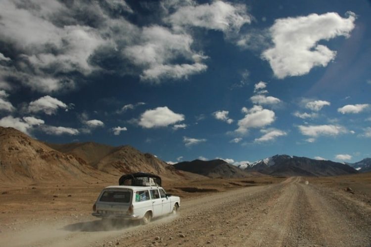
The Pamir Highway, roughly speaking begins in Kyrgyzstan and winds its way through Tajikistan, is one of the world's greatest road trips.
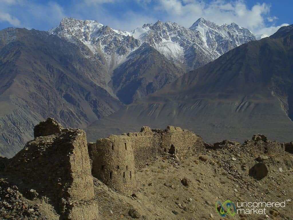
Table of Contents
Pamir Highway Sights, Stories and Highlights
Kyrgyzstan Stops Along the Pamir Highway
Sary Tash
A stopping point for travelers and truck drivers alike in southern Kyrgyzstan. The road forks, one way to Tajikistan, the other to China. If you spend the night, beware. Temperatures are frighteningly low and winds exceptionally brutal. This explains the permanently reddish cheeks you see in our photos of kids there.
Pik (Peak) Lenin: Located 20 kilometers outside of Sary Tash, Pik Lenin (7,134 meters) dwarfs the surrounding plains, as the autumn light bathes some of the most spectacular scenery we’ve ever seen. If you find yourself here in summer, it would be worth taking a few extra days to do some hiking in this region. Peak Lenin is supposedly one of the easier 7,000+ meter (21,000+ feet) mountains to climb, and the trek up to its base camp is challenging, but stunningly beautiful.

Trekking in the Alay Mountains
If you have some time in your schedule, consider stopping off in Sary Tash or Sary Mogul to do some trekking in the Alay Mountains. The mountain scenery is stunning and the day and multi-day treks we did in this area were some of our favorites. More on how to plan and organize a trek in the Alay Mountains. Our Alay Region Experiential Guide also includes other yurt camp stays and trekking options in the Pamir Mountains in Kyrgyzstan, including up to Peak Lenin base camp.
Tajikistan Stops Along the Pamir Highway
Tajik Border Crossing
At 4,282 meters (13,000 feet) near the Kyzyl-Art-Pass, this border crossing is perhaps the most beautiful and the most desolate we’ll ever encounter. Two metal cylindrical buildings sat rusting on the crest of a hill. Several young military conscripts exited as we pulled up and circled the jeep with their guns slung over their arms. After correctly surmising that we posed no threat, they returned to their normal routine of breaking and collecting ice for drinking water in a nearby pond.
Lunch Stop Near Lake Karakul
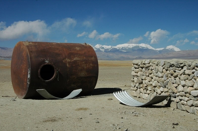
The Pamirs means Roof of the World and we began to understand why as the light and landscape seemed to bend around the edges of the high desert plateaus (4000+ meters or 12,000+ feet). Abandoned, rusted containers took on a surreal, Dali-esque feel to them. Even an outhouse somehow seemed poetic and beautiful in this setting.
Murghab to Langar
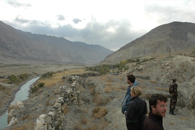
More high desert terrain, a random Bactrian camel and a few salt lakes dot the landscape between Murghab and the Khargush Pass (4344 meters). The road went from bad to worse as we left the main Pamir Highway. Pakistan’s Hindu Kush Mountain Range, with snow-covered peaks at 7,000+ meters (21,000 feet), began to peek through a narrow corridor of Afghan land. Peering into Afghanistan (and at a distance, Pakistan) from across the Pyanj River, we hoped to see camel caravans carrying goods over the roadless terrain. We were a bit late; it seemed that the camels had already gone home for the season.
Langar
Langar marks the start of the Wakhan Valley if you are coming from Murghab. Langar is a friendly and pleasant village to spend the night and is worth a long walk around. The setting is beautiful and the river valley views into the Pamir and Hindu Kush mountain ranges are magnificent. Seek out this kind woman for some pleasant company and conversation in English.

Pamiri Houses
The traditional Pamiri house, huneuni chid, compliments the natural hospitality of the Pamiri people. From the outside, these homes look like simple mud rectangles. The interiors are outfitted with dark wood and are often intricately carved or painted. A large open rectangular area in the middle of the house, ringed by an elevated platform, serves as the main common area where visitors sit, eat and sleep.
The most interesting feature of these homes is the depth of symbolism behind their common geometric design. The five vertical pillars in the main room represent the five Muslim prophets – Fatima, Ali, Mohammed, Hassan and Husain. A skylight in the roof – consisting of four concentric squares representing earth, fire, air and water – illuminates the room. Pamiri home design supposedly dates back almost 2,500 years.
Vrang
Although the Buddhist caves described in the guidebook aren’t much to see, the village kids are. They will lead you up and around the hills to the caves. Vrang also marks a possible starting point for a hike from Peak Karl Marx (6,723 meters) to the Shokh Dara Valley.
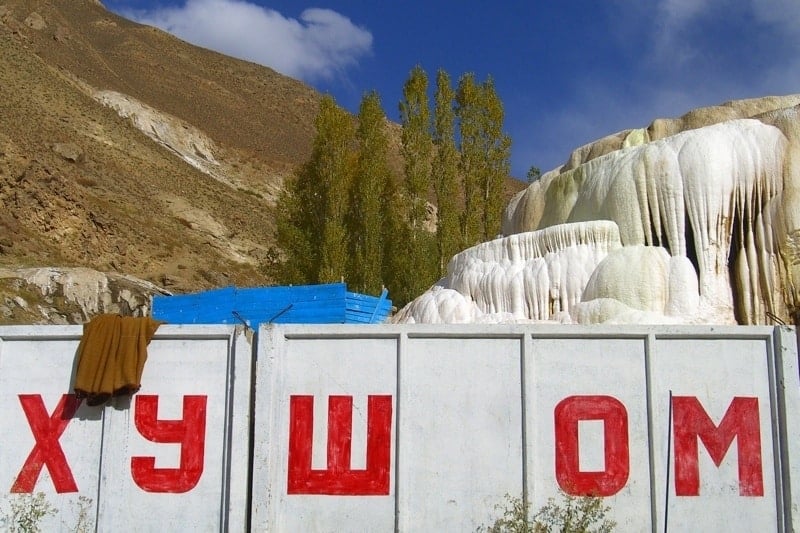
Bibi Fatima Springs
After days without bathing water, the picturesque hot springs above Yamchun Fort are a welcome respite. Even if you can’t bathe, you'll still find yourself thankful for the luxury of warm water. The springs are purported to boost fertility in women; Audrey was advised by the woman running the place to drink as much water as she possibly could.
Khakha Fortress
A 3rd century BC fort that is now serves as a Tajik military border station. We were stopped by several young Tajik conscripts toting AK-47s. They even ran down the hill from their station to greet us. They gruffly asked us in Russian what we were doing there and what we wanted. Audrey, the only quasi-Russian speaker of the bunch, explained that we hoped to see the fort and offered that we had obviously made a mistake and would leave. Not accepting our answer, the soldiers asked to see our passports and documents. We were surrounded by rocky terrain, meaning that no one from the road could see us, including our driver. Audrey lied and said our passports were in the car.
The look on our driver's face (something equivalent to “oh shit”) was precious as the five of us walked out of the rocky area, escorted by three gun-toting soldiers. Once our documents were examined and deemed in order, the soldiers' expressions changed to something resembling smiles. Although we were still all a bit frightened, they insisted on taking us on a tour of the fort and their living areas. One of our French companions plied them with cigarettes to ensure that we stayed on their good side.
Ishkashim
At the Wakhan Valley's western end, Ishkashim is the most populated village of the valley. We stopped by to visit the town market and met some friendly locals along the way. The Afghan town of Ishkashim nearby is connected to Tajikistan by a new bridge built with donations from the Aga Khan. Rumor has it that the border officials will let foreigners into Afghanistan and back to Tajikistan for the weekend market. We didn’t try it since we only had a single-entry Tajik visa, but we’re curious to hear if anyone has.
Garam Chashma
Hot springs set in calcium pools, reminiscent of Pamukkale in Turkey. A pleasant stream runs nearby, making it perfect for a picnic and walk. Although the locals swear by the health benefits of the mineral water, we found it a bit too mineral-laden to consume. Again, people are very friendly. We collected numerous offers to spend the night. Beware of the man who knows every fact and detail of French history; he stumped our French companion with the question of who wrote La Marseillaise.
Khorog
While this regional capital is not full of sights, it is a pleasant place to wind down after several days on the road. It also serves as a jumping-off point for the Wakhan or Shokh Dara Valleys. The Aga Khan, spiritual leader of the Ismaili sect of Shiite Islam and the Pamiri people and founder of numerous schools and universities, has put an emphasis on foreign languages and business skills. It shows. Khorog may have the highest concentration of English speakers in all of Central Asia. At least that’s how it sounded to us.
Pamir Highway People and Landscapes
The extremity of the landscape along the Pamir Highway comes at a price, however. After wearing all of our heavier clothes to stay warm, eating nothing but potatoes, bread and tea, and being without bathing water for five days, we were ready for some features of civilization. Our journey in the Pamirs fortunately knew an end.
For the local Pamiri people, however, the austerity and scarcity of their homeland are not components of an adventure holiday. For them, this is real life, day in and day out.
People and cultures are influenced by their environment. However, the way in which the various people encased in this relatively tiny sub-region of Central Asia closely matched the diversity of their landscape – from its desolate high mountain deserts to its fertile river valleys – was especially fascinating.
A Kyrgyz Outpost in the High Desert
Our first evening in Tajikistan featured a stop in Murghab (3,576 meters), the first town after the Kyrgyz-Tajik border. Its mud-covered houses and converted train wagons conveyed a Wild West look to the town, but abandonment and foreclosure hung heavy in the air. Murghab seemed like a place that should never been inhabited at all, but somehow its ethnic Kyrgyz population has continued to survive.
The combination of elevation and dry climate ensures that almost nothing grows, not even potatoes. Residents here must import all of their food from Kyrgyzstan or China – or bring it in from Dushanbe, the capital of Tajikistan. The prices of basic goods like flour and petrol were high. We were told that cows could not take the freezing temperatures and horses were doomed to heart attacks because of the high elevation (3,800-4,000 meters). So, instead of cows, yaks served as the primary source of meat and the more resilient donkey as the beast of burden.
While we enjoyed our dinner of yak meat and yak yogurt – both of which were surprisingly good – we abided the potatoes and hard bread as we imagined a local life of scarcity. Consider also that we stayed with a relatively wealthy family, whose livelihoods were funded by the annual tourist flow. The abundant fruits, vegetables and herbs of Osh, Kyrgyzstan just two days before seemed almost otherworldly here.
Weathered faces and tired smiles began to make sense in this harsh environment. As we walked around the town market the next morning, people were curious as to where we were from; they invited us to chat. A palpable sense of fatigue and hopelessness matched the surroundings, however.
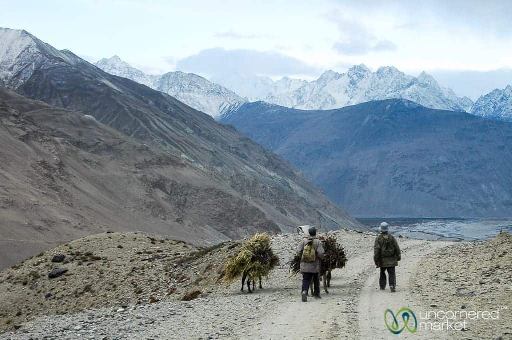
The next day we left the high desert behind for the Wakhan Valley, a comparatively lush river valley that traces the border between Tajikistan and Afghanistan. No more than 100 miles separates Murghab and the Wakhan Valley, but the distance and the landscape were enough to form a cultural chasm between these vastly different areas.
Skirting Afghanistan through the Wakhan Valley
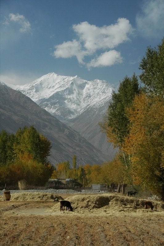
Life in the Wakhan Valley is not easy by any stretch – locals collect water at mountain springs, agriculture is still limited, public transport is almost non-existent and roads are often barely passable, and services and supplies are limited, but the natural environment was noticeably more hospitable than the high desert we had just traveled through. Trees, mountains and fields compose the visual space in the Wakhan Valley and make autumn a truly spectacular time to take it all in. For us, early October featured rich autumn colors in the foreground and snow-dusted sepia-toned mountains in the background.
Although life is also difficult in the Wakhan Valley, locals are able to grow enough food. According to some estimates, they’ve reached 70% agricultural sustainability. This relative abundance is reflected in their simple and sincere hospitality. Even though the Wakhan Valley is secluded and its people know limited interaction with the outside world, Pamiri people are exceptionally welcoming.
As we walked through villages, we were regularly invited for tea or offered fresh milk and bread. People were happy to show us their Pamiri homes and have a chat, whether or not we shared a common language. While we appreciated every invitation, we had to respectfully decline some due to time constraints and full stomachs.
Homestays Along the Pamir Highway
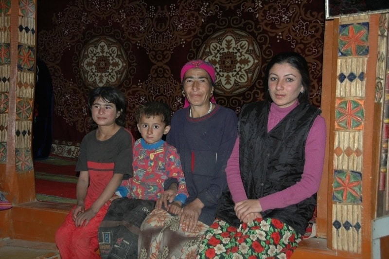
For our second night in the Wakhan Valley, we decided to stay in a small village. The Wakhan Valley does not have a network of hotels or hostels, but the hospitality of its people fills the void. We asked our driver to stop at the only store in the village of Namadguti, more or less in the middle of nowhere. We figured this would yield a genuine Pamiri experience.
The driver talked to a local man standing outside a local shop, but he didn’t have any ideas. Dan suggested we ask the local shopkeeper. Sure enough, this woman lived behind the shop and invited us to stay with her family. Our travel experience shows that women almost always seem to have a solution.
Our host was a thin, weathered woman with a kind, tired smile. After our inquiry, she closed her shop and showed us to her family home, a beautiful Pamiri-style house with carved pillars. Four girls, ranging from six to twenty years old, flitted around us excitedly and brought us endless bowls of apples and tea as we began to settle in. The floors were decorated in colorful carpets and mattresses, making for a warm and homey environment in spite of the setting sun and growing cold outside.
After dinner, several of our travel companions began making balloon animals – dogs, swans, bears and other unidentifiables. The youngest child, a three-year old boy, didn't know what to make of these new gifts. Before long, the elevated floor of our hostess’ common room was covered with a balloon animal menagerie. Throughout the evening, we exchanged English lessons for lessons of Tajik and Pamiri with the sisters. Although there was a little mutual understanding in English and Russian, most of the communication was through smiles and body language. The mother sat watching the whole scene, smiling peacefully as she knitted thick leg warmers in preparation for winter.
The next morning, as we departed, we asked our hostess what we owed her for our night’s accommodation and food. She asked for less than $1.50 per person. We insisted on leaving some more money, using the children as an excuse so as not to offend her; we received a bushel of apples in return.
The family’s generous spirit was moving; we almost didn't want to leave. Warm water, vegetables and heat awaited us in Khorog. Spending a few days in the high and remote Pamir Mountains reminded us how closely we human beings are linked to our environments. Even though basic necessities like food and clean water were sometimes a struggle, Pamiri people shared what they could and welcomed us to their homes.
Transport to and from the Pamir Mountains:
If you can, try to hire transport that will take you the entire way from Osh to Khorog (or Dushanbe, whichever is your final destination). This will ensure that you are never stuck anywhere or waste time trying to coordinate your next transport.
In the years since we did our Pamir Highway road trip we've worked frequently with Visit Alay based in Osh, Kyrgyzstan and know the owner/founder quite well. They run a lot of different Pamir Highway transport and tour options, either from Osh, Murghab, Dushanbe or Bishkek. You can even rent a car for self-drive, but we wouldn't recommend that unless you have a lot of experience driving in challenging terrains and know how to fix a 4-wheel drive car.
Our own experience included:
- Osh to Murghab: We hired a Russian UAZ jeep through a contact we found on a travel bulletin board. The jeep fit five travelers plus the driver, snuggly. We stopped overnight in Sary Tash and arrived in Murghab the next afternoon.
- Murghab to Khorog via the Wakhan Valley: If you have a lot of time and flexibility, you can conceivably hitchhike this route, but beware that vehicles of any sort are few and far between, particularly outside of summer. We hired a driver with jeep to take us the 400km over three days. The cost was $300. We also paid for his return trip from Khorog to Murghab since he couldn’t find any passengers that needed to return. ACTED in Murghab can set you up with a driver for a slightly higher fee. Hang around the market in Murghab or just walk through town – available drivers will find you since there are not many tourists.
- Other transport options: There are more regular marshrutkas (shared vehicles) going from Murghab to Khorog and vice versa on the main Pamir Highway. Cost is around $25/person. Go early to the Murghab or Khorog markets. From Khorog, there are infrequent buses going to Ishkashim and other nearby villages.
- Transport to/from Dushanbe: By plane, it's a quick and terrifying 45 minutes on Tajik Air. By car/jeep, it's 15 hours if you're lucky and up to 24 hours if you're not.
Accommodation in the Pamir Mountains:
- Sary Tash: There are a couple of home-stays/guest houses in town; we just stayed at the place our driver recommended. Simple sleeping arrangements and food (fried potatoes) for around $6-$8. Dress warmly. Temperatures dropped to -15 Celsius when we were there in early October.
- Murghab: We stayed with our driver for 10 Tajik somoni ($6), including dinner and breakfast. There are several other guesthouses in town.
- Wakhan Valley: ACTED offers a series of home stays that your driver is likely to know about. Or, just ask around at the local store. Expect to pay from 5-30 somoni, depending upon the place and food options. Don't expect water for bathing and bring toilet paper with you for the outhouses. We bathed, very gratefully, at the hot springs in Bibi Fatima and Garam Chasma.
- Khorog: For its lovely hosts, delicious food and hot showers, The Pamir Lodge is a great place to stay in Khorog. The Pamir Lodge is located across the river from the market near a school and friendly bee keeper whose bees produce some of the world’s strappiest honey.
Food and Eating in the Pamir Mountains
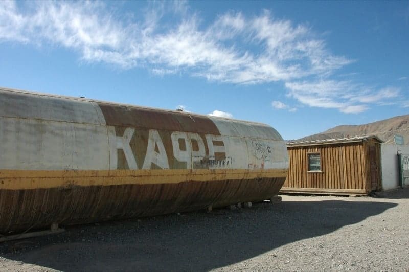
You don't come to the Pamirs to eat. In Murghab, we ate yak meat and yak yogurt, both of which were both surprisingly tasty. After that, we mainly ate fried potatoes, a grain resembling bulghur wheat, bread and tea until we reached saturation…and the town of Khorog. A wider variety of food may be available during the summer months, but pack power bars, nuts and dried fruit and other goodies to get you, your mates, and your driver through sparse eating opportunities.
We highly recommend ordering kurtob, a fresh, light layered dish made with strips of bread, homemade yogurt, onions, tomatoes and coriander, at the Pamir Lodge in Khorog. A welcome treat after a week of bland fried potatoes and uninspired bread.
Pamir Highway and Wakhan Valley Sites
The following is a bulleted list of sites and markers along the famed Pamir Highway, all the way from Osh, Kyrgyzstan to Khorog, Tajikistan. This particular list follows the southern route (Langar to Ishkashim) along the Wakhan Valley that traces the Tajik-Afghan border.
We offer this up not for our casual readers, but for those headed to the Pamir Mountain region. We found the Lonely Planet Central Asia to be mildly confusing, particularly when we tried to determine the most significant points of interest in sequence along the Pamir Highway. This list may also help you in labeling all of the photos you’ll likely take on your journey along the Pamir Highway. Even armed with a GPS geotagging device, it was helpful to have this list to reconcile where we’d been with all the photos we took.
In order to derive the maximum amount of value from your drive along the Pamir Highway, consider carrying this list, your guide book (e.g. Lonely Planet) and a detailed map of the Pamir Mountain region and the M41 Highway.
START: Osh, Kyrgyzstan
- Bas Bulak
- Papan Reservoir off to the right
- Along the Toldik river
- Chigirchik Pass at 2406 meters
- Gulcho
- Murdash
- Zhergetal
- Kichi Karakol
- Taldyk Pass at 3615 meters
- Sary Tash
- 21 of the 33 km on A372 to Sary Mogol
- Pik Lenina at 7134 meters
- Kyrgyz border post at Bordoba
- Tajik Border
- Kyzyl-Art Pass
- Markansu
- Uy Bulak Pass at 4232 meters
- Eastern side of lake, just before Kara Kul village, home stay and saka kurgan and solar calendar
- Lake Karakul at 3914 meters
- Just before Akbajtal Pass, caravanserai
- Akbajtal Pass at 4655 meters
- Tabortakbajtal
- Chechekty (museum, too)
- Murghab
- Saly Unkjur Cave
- Mamazir, home stay
- Neizatash Pass at 4314 meters
- Chatyr Tash (rock formation)
- Off road to Bash Gumbez
- Aluchur (Alichur) at 3863 meters
- Lake Sasyk Kul
- Lake Tuz Kul
- Off M41
- Khargush Pass at 4344 meters
- Hausibeks Viewpoint
- Khargush (on Afghan border)
- Past Tilabay Nature Reserve on left
- Castle and petroglyphs (just before Langar)
- Langar
- Hisor
- Zong (castle)
- Zugvand (solar calendar)
- Shirgin (mazar, shrine)
- Drizh
- Nizhgar
- Iniv
- Vrang (castle, shrine, cave, museum) – kids led us up
- Vnukut
- Yamg (solar calendar, museum)
- Yamchun (baths, castle)
- Vichkut
- Tuggoz
- Ptup (mazar/shrine)
- Navabad
- Zmudg (solar calendar, shrine, dune)
- Past Pik Karl Marx at 6723 meters
- Shitkharv (waterfall, mazar/shrine)
- Darshai (castle, petroglyphs, mazar/shrine)
- Togakhona
- Boibar (Ramanit)
- Udit
- Namadgut-Bolo – where we stayed
- Namadgut-Poyon (mazar/shrine)
- Dasht
- Ryn (solar calendar, mazar/shrine)
- Pyanj River
- Ishkashim (at 2510 meters)
- Border cross at Darwan (to Sultan Ishkashim, Afghanistan)
- Sumjin
- Yakhshwol
- Malvoj (hot spring)
- Barshor
- Kozideh (can off-road to Bagush)
- Shanbedeh
- Voeg
- Sist
- Kuh-i La’l
- Andarob (off to Snib, Garam-Chashma)
- Khaskhorug
- Shichozg
- Nishusp
- Pish (café)
- Gozhak
Hello Audrey and Daniel,
It was very exciting to read the story of your encounter with the soldiers! Bravo, great presence of mind! I was also quite surprised that Fatima is believed to be a prophet despite being a female. The last I heard, it said that there were 25 prophets in Islam. Although the number seems to vary depending on which brand one is following. Hopefully some day I will be able to visit the places too!
thanks!
Priyank
@Priyank: Fortunately, my instincts were right when we encountered these soldiers. I just tried to keep myself calm so that they would also stay calm.
This area is a really unique part of the world and the hospitality is humbling. It’s a bit difficult to get to, but I highly recommend a visit.